I mention this application because it illustrates how powerful open source GIS applications have become. I thought I would make a brief comparison here to give a sense of how many of the traditionally ArcGIS functions are actually "doable" in QGIS with one of the myriad plugins available such as GRASS or PostGIS.
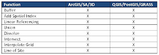
This table illustrates a few of the geoprocesses that both the ESRI stack and the OS stack handle very well. The only real difference is the cost. The ESRI stack above represents about $25,000 (requires ArcInfo for Linear Referencing and Spatial Analyst for LOS) where as the OS stack is free. I am a firm believer in the right tool for the job and I believe that ESRI still has an advantage in cartographic output but what I think this illustation shows is that you MUST make a proper needs assessment before deciding on a GIS implementation. You may find that your current and future requirments will fit well with an open source deployment that will potentially save you thousands of dollars.
Don't get me wrong, I am not averse to an ESRI or any other commercial vendor deployment. I am only saying that, when looking at developing a GIS, it is worth considering open source as part of that strategy. In fact larger commercial developers such as ESRI and Safe are starting to support open source platforms such as PostgreSQL/PostGIS.
I will be posting a link to the QGIS plugin I mentioned at the begining on this site very soon so check back often. I will also be announcing it's release on Twitter and in a number of LinkedIn formus such as GIS, Geomatics and GIS Professionals so stay tuned.
1 comment:
Very cool. Looking forward to your plugin. This sounds like something really interesting.
Post a Comment