Showing posts with label PostGIS. Show all posts

March 19, 2009

Who needs ArcMap?

Over the past month I have been working on a Python plugin for Quantum GIS (QGIS) that allows the user to access the geoprocessing functionality of PostGIS without leaving the QGIS environment. I call it PgQuery for QGIS for anyone that might care. I have tried to make the plugin easy and intuitive to use with some click/double click functionality to insert PostGIS functions and tables into the query statements. That is the end of my sales pitch for this open source application, it is currently being tested by some associates and I will release it to the OS community very soon.

I mention this application because it illustrates how powerful open source GIS applications have become. I thought I would make a brief comparison here to give a sense of how many of the traditionally ArcGIS functions are actually "doable" in QGIS with one of the myriad plugins available such as GRASS or PostGIS.
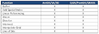

This table illustrates a few of the geoprocesses that both the ESRI stack and the OS stack handle very well. The only real difference is the cost. The ESRI stack above represents about $25,000 (requires ArcInfo for Linear Referencing and Spatial Analyst for LOS) where as the OS stack is free. I am a firm believer in the right tool for the job and I believe that ESRI still has an advantage in cartographic output but what I think this illustation shows is that you MUST make a proper needs assessment before deciding on a GIS implementation. You may find that your current and future requirments will fit well with an open source deployment that will potentially save you thousands of dollars.

Don't get me wrong, I am not averse to an ESRI or any other commercial vendor deployment. I am only saying that, when looking at developing a GIS, it is worth considering open source as part of that strategy. In fact larger commercial developers such as ESRI and Safe are starting to support open source platforms such as PostgreSQL/PostGIS.

I will be posting a link to the QGIS plugin I mentioned at the begining on this site very soon so check back often. I will also be announcing it's release on Twitter and in a number of LinkedIn formus such as GIS, Geomatics and GIS Professionals so stay tuned.

March 12, 2008

ArcGIS Server vs. Mapserver/PostGIS

I know that ArcGIS server is supposed to be a true example of SaaS and the Mapserver/PostGIS example I have given is likely considerd something else but I would like to share an experience on a project that spans both worlds. About 5 years ago the company that I was working for at the time got a contract to build an online database/spatial data managment system for a Canadian Government Agency. Originally they required a proof of concept so we decided to build this thing using open source technologies. We very quickly found that UMN Mapserver combined with PostGIS/PostgreSQL and a couple of other nearly free software titles would do everything we needed. By the time we were finished we had a highly interactive tool that gave the user access to such things as dynamic cross sections, dynamic drill logs including down hole temperatures, the ability to upload photos and add them as points on the map and a dynamic 3D visualization tool. The grand total for software expenses was under $2000 CDN.

Anyway, to make a long story even longer, about a year and a half ago the client decided that they wanted to host the application themselves. As they are completely an ESRI shop we were contracted again to migrate the application to ArcIMS and ArcGIS Server. This task did not come without several headaches that's for sure but we managed to get much of the application migrated. The one thing that was impossible was the ability to migrate the 3D visualization tool. Apparently ArcGIS Server won't allow you to consume their ArcScene objects without a thick client such as ArcGIS Explorer or full blown ArcScene. The client did not want their clients to download any software for this purpose so we ended up going with the much less versitile solution of creating a number of static views as jpeg files. This also required some additional programming to create a viewer for accessing the images. Needless to say this required an adjustment to the scope of the project and some creative negotiation with our client.

So why am I telling you all this; keeping in mind that the software we were using with the original application cost about $300 to generate the 3D views. Why is it that ESRI couldn't provide this functionality in thier much more expensive software. Please don't get the idea that I am anti ESRI because I think ArcGIS Server is a phenominal product but I don't understand why, with the advent of such technologies as Google Earth and Microsofts Virtual Earth, ESRI didn't throw in the ability to view snapshots of the 3D scenes without a thick client.

As the project manager for this application I made an official improvement request to ESRI but I haven't heard whether this improvement has been made as of yet. I understand that ESRI as the largest supplier of GIS software can't include everything into thier applications but I just thought it was a no brainer given my comments about virtual earth technology and the web.

Please let me know what you think about this especially if you are involved in creating rich web applications for your clients or employers.

-Gerry-